Geolocate

Whitesburg topographic map

Click on the map to display elevation.

About this map

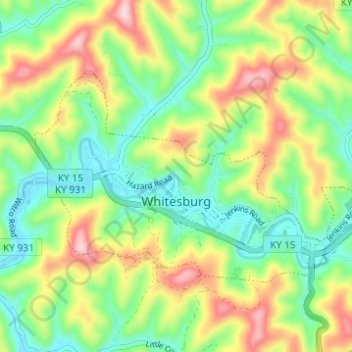
Name: Whitesburg topographic map, elevation, terrain.

Location: Whitesburg, Letcher County, Kentucky, United States (37.10708 -82.85159 37.13676 -82.78998)

Average elevation: 446 m

Minimum elevation: 338 m

Maximum elevation: 620 m

Other topographic maps

Click on a map to view its topography, its elevation and its terrain.

Mayking

United States > Kentucky > Letcher County

Average elevation: 448 m

Roxana

United States > Kentucky > Letcher County

Average elevation: 425 m

Seco

United States > Kentucky > Letcher County

Average elevation: 460 m

Ice

United States > Kentucky > Letcher County

Average elevation: 445 m

Eolia

United States > Kentucky > Letcher County

Average elevation: 612 m

Gear up for your next adventure:

🧶550 Survival Paracord - Versatile utility cord for emergency repairs and rigging
🧴Waterproofing Spray - Restore the DWR coating on jackets and tents
🧦Crew Hiking Socks - Comfortable socks for long-distance hikes
🥤Collapsible Travel Cup - Saves space and weight in your mess kit
🛌Down Sleeping Bag - Superior warmth-to-weight ratio for cold nights

As an Amazon Associate, this site earns from qualifying purchases at no extra cost to you.