Geolocate

Ruffano topographic map

Click on the map to display elevation.

About this map

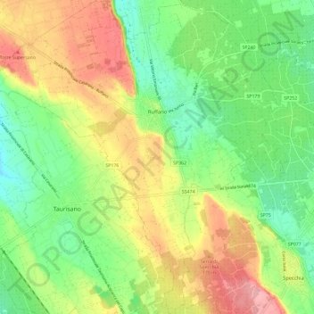
Name: Ruffano topographic map, elevation, terrain.

Location: Ruffano, Lecce, Apulia, Italy (39.92682 18.18389 40.01561 18.29947)

Average elevation: 129 m

Minimum elevation: 81 m

Maximum elevation: 192 m

Other topographic maps

Click on a map to view its topography, its elevation and its terrain.

Porto Miggiano

Italy > Apulia > Lecce > Santa Cesarea Terme

Average elevation: 48 m

Torre Rinalda

Italy > Apulia > Lecce > Lecce

Average elevation: 1 m

Santa Maria di Leuca

Italy > Apulia > Lecce

Average elevation: 41 m

Giorgilorio

Italy > Apulia > Lecce > Surbo > Giorgilorio

Average elevation: 43 m

Porto Badisco

Italy > Apulia > Lecce > Otranto

Average elevation: 38 m

Gear up for your next adventure:

🥾Waterproof Hiking Boots - Essential footwear for rugged terrain and wet Canadian trails
🌡️Emergency Mylar Blankets - Compact thermal protection for unexpected nights outdoors
Camping Essentials - All-in-one gear for a comfortable camping trip
🛁Quick-Dry Microfiber Towel - Space-saving towel that dries rapidly on the move
🧴Insect Repellent - Protect yourself from bugs during outdoor adventures

As an Amazon Associate, this site earns from qualifying purchases at no extra cost to you.