
Make a donation
Gear up for your next adventure:
As an Amazon Associate, this site earns from qualifying purchases at no extra cost to you.
Saint-Gilles-les-Hauts topographic map
Click on the map to display elevation.
Make a donation
Gear up for your next adventure:
As an Amazon Associate, this site earns from qualifying purchases at no extra cost to you.
Saint-Gilles-les-Hauts
Saint-Gilles les Hauts est un lieu-dit de l'île de La Réunion, département et région d'outre-mer français dans le sud-ouest de l'océan Indien. Il constitue un quartier de la commune de Saint-Paul au sud du centre-ville. A 315 mètres d'altitude.
Make a donation
Gear up for your next adventure:
As an Amazon Associate, this site earns from qualifying purchases at no extra cost to you.
About this map
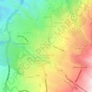
Name: Saint-Gilles-les-Hauts topographic map, elevation, terrain.
Average elevation: 341 m
Minimum elevation: 114 m
Maximum elevation: 610 m
Make a donation
Gear up for your next adventure:
As an Amazon Associate, this site earns from qualifying purchases at no extra cost to you.
Other topographic maps
Click on a map to view its topography, its elevation and its terrain.
Ravine Saint-Gilles
France > La Réunion > Saint-Paul > Saint-Gilles-les-Hauts > Village de l'Éperon
Average elevation: 310 m
Make a donation
Gear up for your next adventure:
As an Amazon Associate, this site earns from qualifying purchases at no extra cost to you.