Geolocate

Rizzoli topographic map

Click on the map to display elevation.

About this map

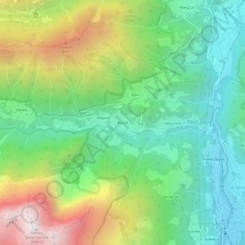
Name: Rizzoli topographic map, elevation, terrain.

Location: Rizzoli, Ardesio, Bergamo, Lombardia, 24020, Italia (45.92852 9.88243 45.96852 9.92243)

Average elevation: 1,125 m

Minimum elevation: 535 m

Maximum elevation: 2,228 m

Other topographic maps

Click on a map to view its topography, its elevation and its terrain.

Piazzolo

Italia > Lombardia > Bergamo > Ardesio

Average elevation: 963 m

Gear up for your next adventure:

Bushcraft Tarp - Versatile emergency shelter or gear protection
Lightweight Backpacking Tent - Compact tent for efficient hiking trips
🧣Merino Neck Gaiter - Protects against wind, sun, and cold at high altitudes
🥤Collapsible Travel Cup - Saves space and weight in your mess kit
🔦LED Headlamp - Hands-free lighting for early morning starts or late finishes

As an Amazon Associate, this site earns from qualifying purchases at no extra cost to you.