
Make a donation
Gear up for your next adventure:
As an Amazon Associate, this site earns from qualifying purchases at no extra cost to you.
Bermeo topographic map
Click on the map to display elevation.
Make a donation
Gear up for your next adventure:
As an Amazon Associate, this site earns from qualifying purchases at no extra cost to you.
Bermeo
Das Klima in Bermeo ist von der feuchten Meeresluft bestimmt, die von den Meeresströmungen beeinflusst wird, mit milden Temperaturen fast das ganze Jahr über. Die Windstärken sind im Frühling oder Herbst höher. Die mittlere Temperatur ist 20 °C im Sommer und 8 °C im Winter.
Make a donation
Gear up for your next adventure:
As an Amazon Associate, this site earns from qualifying purchases at no extra cost to you.
About this map
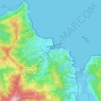
Name: Bermeo topographic map, elevation, terrain.
Average elevation: 126 m
Minimum elevation: -4 m
Maximum elevation: 642 m
Make a donation
Gear up for your next adventure:
As an Amazon Associate, this site earns from qualifying purchases at no extra cost to you.
Other topographic maps
Click on a map to view its topography, its elevation and its terrain.
Make a donation
Gear up for your next adventure:
As an Amazon Associate, this site earns from qualifying purchases at no extra cost to you.
Biaritz
Spanien > Autonome Gemeinschaft Baskenland > Arabako lautada / Llanada Alavesa > Agurain / Salvatierra
Average elevation: 599 m
Cabo Higuer
Spanien > Autonome Gemeinschaft Baskenland > Bidasoa Beherea / Bajo Bidasoa > Hondarribia/Fontarrabie
Average elevation: 12 m
La Mana
Spanien > Autonome Gemeinschaft Baskenland > Karrantza Harana / Valle de Carranza
Average elevation: 999 m