Geolocate

Fermont topographic map

Click on the map to display elevation.

About this map
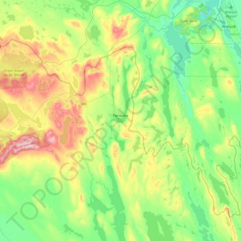
Name: Fermont topographic map, elevation, terrain.

Location: Fermont, Caniapiscau (MRC), Côte-Nord, Quebec, G0G 1J0, Canada (52.69916 -67.44728 52.87631 -66.97084)

Average elevation: 633 m

Minimum elevation: 495 m

Maximum elevation: 907 m

Other topographic maps

Click on a map to view its topography, its elevation and its terrain.
Gear up for your next adventure:

🩹Moleskin Blister Pads - Direct protection for painful foot pressure points
🧤Insulated Winter Gloves - Heavy-duty protection for sub-zero Canadian adventures
🧦Crew Hiking Socks - Comfortable socks for long-distance hikes
🍽️Titanium Camping Spork - Ultralight and indestructible eating utensil
☕Camping Coffee Maker - Brew fresh coffee anywhere on the topographic map

As an Amazon Associate, this site earns from qualifying purchases at no extra cost to you.