
Thank you for supporting this site ❤️
Make a donation
Make a donation
Gear up for your next adventure:
As an Amazon Associate, this site earns from qualifying purchases at no extra cost to you.
Col de la Perche topographic map
Click on the map to display elevation.
Thank you for supporting this site ❤️
Make a donation
Make a donation
Gear up for your next adventure:
As an Amazon Associate, this site earns from qualifying purchases at no extra cost to you.
Col de la Perche
Le col de la Perche (catalan : Coll de la Perxa), situé à 1 581 m d'altitude, est un col de montagne des Pyrénées, lieu de passage du Conflent vers la Cerdagne. Il se trouve sur la route des cols.
Thank you for supporting this site ❤️
Make a donation
Make a donation
Gear up for your next adventure:
As an Amazon Associate, this site earns from qualifying purchases at no extra cost to you.
About this map
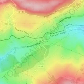
Name: Col de la Perche topographic map, elevation, terrain.
Average elevation: 1,608 m
Minimum elevation: 1,502 m
Maximum elevation: 1,717 m
Thank you for supporting this site ❤️
Make a donation
Make a donation
Gear up for your next adventure:
As an Amazon Associate, this site earns from qualifying purchases at no extra cost to you.