
Make a donation
Gear up for your next adventure:
As an Amazon Associate, this site earns from qualifying purchases at no extra cost to you.
Port Salerno topographic map
Click on the map to display elevation.
Make a donation
Gear up for your next adventure:
As an Amazon Associate, this site earns from qualifying purchases at no extra cost to you.
About this map
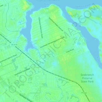
Name: Port Salerno topographic map, elevation, terrain.
Location: Port Salerno, Martin County, Florida, 34887, United States (27.12511 -80.21102 27.16672 -80.16508)
Average elevation: 6 m
Minimum elevation: -4 m
Maximum elevation: 15 m
Make a donation
Gear up for your next adventure:
As an Amazon Associate, this site earns from qualifying purchases at no extra cost to you.
Other topographic maps
Click on a map to view its topography, its elevation and its terrain.
Jonathan Dickinson State Park
United States > Florida > Martin County > Hell Gate
Average elevation: 5 m
Make a donation
Gear up for your next adventure:
As an Amazon Associate, this site earns from qualifying purchases at no extra cost to you.