Geolocate

Parc Forestal topographic map

Click on the map to display elevation.

About this map

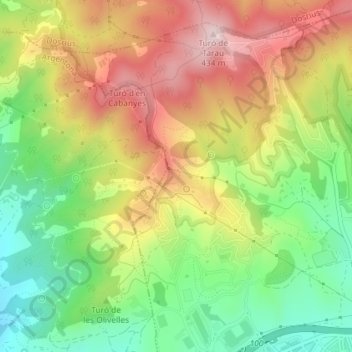
Name: Parc Forestal topographic map, elevation, terrain.

Location: Parc Forestal, Mataró, Maresme, Barcelona, Cataluña, España (41.56577 2.42580 41.56873 2.43169)

Average elevation: 238 m

Minimum elevation: 68 m

Maximum elevation: 427 m

Other topographic maps

Click on a map to view its topography, its elevation and its terrain.

Turó de Cerdanyola

España > Cataluña > Maresme > Mataró

Average elevation: 90 m

Gear up for your next adventure:

Camping Coffee Maker - Brew fresh coffee anywhere on the topographic map
🧴Insect Repellent - Protect yourself from bugs during outdoor adventures
🥾Approach Shoes - Shoes designed for climbing approaches and rugged trails
🧤Insulated Winter Gloves - Heavy-duty protection for sub-zero Canadian adventures
🕶️Polarized Sunglasses - Reduces glare from snow and water at high elevations

As an Amazon Associate, this site earns from qualifying purchases at no extra cost to you.