Geolocate

Nalbach topographic map

Click on the map to display elevation.

About this map

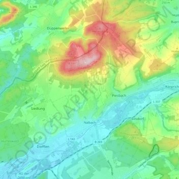
Name: Nalbach topographic map, elevation, terrain.

Location: Nalbach, Landkreis Saarlouis, Saarland, 66809, Germany (49.36685 6.74640 49.41586 6.85503)

Average elevation: 252 m

Minimum elevation: 183 m

Maximum elevation: 406 m

Other topographic maps

Click on a map to view its topography, its elevation and its terrain.

Michelbach

Germany > Saarland > Landkreis Saarlouis

Average elevation: 288 m

Gear up for your next adventure:

🔦UV Flashlight - Detect minerals or specific insects in the dark
📷Outdoor Action Camera - Capture high-elevation views and rugged adventures
🧊Insulated Water Bottle - Keeps drinks cold in summer and prevents freezing in winter
🥾Trail Hiking Boots - Supportive boots for rough trails
🩹Moleskin Blister Pads - Direct protection for painful foot pressure points

As an Amazon Associate, this site earns from qualifying purchases at no extra cost to you.