
Thank you for supporting this site ❤️
Make a donation
Make a donation
Gear up for your next adventure:
As an Amazon Associate, this site earns from qualifying purchases at no extra cost to you.
Calmazzo topographic map
Click on the map to display elevation.
Thank you for supporting this site ❤️
Make a donation
Make a donation
Gear up for your next adventure:
As an Amazon Associate, this site earns from qualifying purchases at no extra cost to you.
About this map
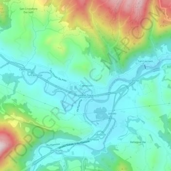
Name: Calmazzo topographic map, elevation, terrain.
Location: Calmazzo, Fossombrone, Pesaro e Urbino, 61034, Italia (43.65741 12.73204 43.69741 12.77204)
Average elevation: 254 m
Minimum elevation: 104 m
Maximum elevation: 660 m
Thank you for supporting this site ❤️
Make a donation
Make a donation
Gear up for your next adventure:
As an Amazon Associate, this site earns from qualifying purchases at no extra cost to you.