
Fareham topographic map
Click on the map to display elevation.
About this map
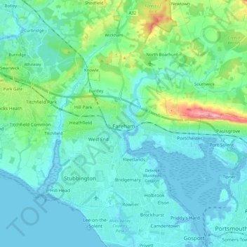
Name: Fareham topographic map, elevation, terrain.
Location: Fareham, Hampshire, England, United Kingdom (50.80894 -1.31291 50.89901 -1.11229)
Average elevation: 21 m
Minimum elevation: -4 m
Maximum elevation: 128 m
Other topographic maps
Click on a map to view its topography, its elevation and its terrain.
Freefolk
United Kingdom > England > Hampshire > Basingstoke and Deane > Whitchurch
Average elevation: 101 m
Basingstoke
United Kingdom > England > Hampshire > Basingstoke and Deane
Situated in a valley through the Hampshire Downs at an average elevation of 88 metres (289 ft) Basingstoke is a major interchange between Reading, Newbury, Andover, Winchester, and Alton, and lies on the natural trade route between the southwest of England and London. The area had been something of an…
Average elevation: 107 m
Bashley
United Kingdom > England > Hampshire > New Forest > New Milton > Bashley
Average elevation: 49 m
Butlocks Heath
United Kingdom > England > Hampshire > Eastleigh > Butlocks Heath
Average elevation: 20 m