Geolocate

Brandon topographic map

Click on the map to display elevation.

About this map

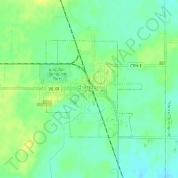
Name: Brandon topographic map, elevation, terrain.

Location: Brandon, Fond du Lac County, Wisconsin, 53919, United States (43.72764 -88.79153 43.74228 -88.77019)

Average elevation: 305 m

Minimum elevation: 295 m

Maximum elevation: 315 m

Other topographic maps

Click on a map to view its topography, its elevation and its terrain.

Waucousta

United States > Wisconsin > Fond du Lac County

Average elevation: 316 m

Eldorado

United States > Wisconsin > Fond du Lac County

Average elevation: 267 m

Gear up for your next adventure:

🛶Canoe Life Vest - Safety vest for water sports
🔦LED Flashlight - Powerful and long-lasting flashlight for camping and emergencies
🥾Approach Boots - Comfortable boots for hiking and climbing approaches
Lightweight Camping Tent - Portable shelter optimized for Canadian backcountry camping
🧢Sun Protection Cap - Breathable cap to protect from sun exposure

As an Amazon Associate, this site earns from qualifying purchases at no extra cost to you.