
Make a donation
Gear up for your next adventure:
As an Amazon Associate, this site earns from qualifying purchases at no extra cost to you.
Sobieszów topographic map
Click on the map to display elevation.
Make a donation
Gear up for your next adventure:
As an Amazon Associate, this site earns from qualifying purchases at no extra cost to you.
About this map
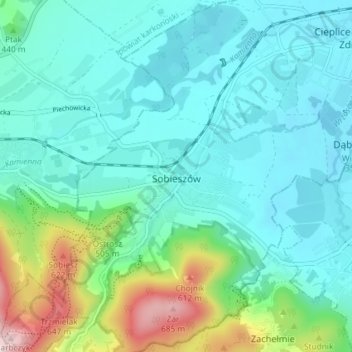
Name: Sobieszów topographic map, elevation, terrain.
Average elevation: 411 m
Minimum elevation: 335 m
Maximum elevation: 704 m
Make a donation
Gear up for your next adventure:
As an Amazon Associate, this site earns from qualifying purchases at no extra cost to you.
Other topographic maps
Click on a map to view its topography, its elevation and its terrain.
Karkonosze
Poland > Lower Silesian Voivodeship > Jelenia Góra
The Giant Mountains, Krkonoše, or Karkonosze (Czech: [ˈkr̩konoʃɛ] , Polish pronunciation: [karkɔˈnɔʂɛ] , German: Riesengebirge pronounced [ˈʁiːzn̩ɡəˌbɪʁɡə] ), are a mountain range located in the north of the Czech Republic and the south-west of Poland, part of the Sudetes mountain system…
Average elevation: 1,196 m