
Make a donation
Gear up for your next adventure:
As an Amazon Associate, this site earns from qualifying purchases at no extra cost to you.
Lower Gwynedd Township topographic map
Click on the map to display elevation.
Make a donation
Gear up for your next adventure:
As an Amazon Associate, this site earns from qualifying purchases at no extra cost to you.
About this map
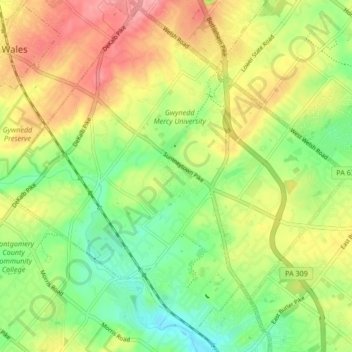
Name: Lower Gwynedd Township topographic map, elevation, terrain.
Average elevation: 100 m
Minimum elevation: 57 m
Maximum elevation: 148 m
Make a donation
Gear up for your next adventure:
As an Amazon Associate, this site earns from qualifying purchases at no extra cost to you.
Other topographic maps
Click on a map to view its topography, its elevation and its terrain.
Worcester
United States > Pennsylvania > Montgomery County > Worcester Township
Average elevation: 93 m
Wyncote
United States > Pennsylvania > Montgomery County > Cheltenham Township
Average elevation: 92 m
Make a donation
Gear up for your next adventure:
As an Amazon Associate, this site earns from qualifying purchases at no extra cost to you.
Mount Vernon Gardens
United States > Pennsylvania > Montgomery County > Abington Township
Average elevation: 93 m
Cynwyd Estates
United States > Pennsylvania > Montgomery County > Lower Merion Township
Average elevation: 80 m
Bob White Farms
United States > Pennsylvania > Montgomery County > Upper Merion Township
Average elevation: 95 m
Make a donation
Gear up for your next adventure:
As an Amazon Associate, this site earns from qualifying purchases at no extra cost to you.
Lafayette Park
United States > Pennsylvania > Montgomery County > Upper Merion Township > King of Prussia
Average elevation: 54 m
Morganville
United States > Pennsylvania > Montgomery County > Upper Moreland Township > Willow Grove
Average elevation: 81 m
Zieglersville
United States > Pennsylvania > Montgomery County > Lower Frederick
Average elevation: 83 m
Make a donation
Gear up for your next adventure:
As an Amazon Associate, this site earns from qualifying purchases at no extra cost to you.
Fulmor
United States > Pennsylvania > Montgomery County > Upper Moreland Township
Average elevation: 79 m
Shirks Corner
United States > Pennsylvania > Montgomery County > Upper Salford Township
Average elevation: 80 m
Ridge Estates
United States > Pennsylvania > Montgomery County > Lower Pottsgrove Township > Ridge Estates
Average elevation: 92 m
Ardmore
United States > Pennsylvania > Montgomery County > Lower Merion Township
Average elevation: 98 m
Make a donation
Gear up for your next adventure:
As an Amazon Associate, this site earns from qualifying purchases at no extra cost to you.
Harleysville
United States > Pennsylvania > Montgomery County > Lower Salford Township
Average elevation: 91 m
Meadowbrook
United States > Pennsylvania > Montgomery County > Abington Township
Average elevation: 66 m
Mount Pleasant
United States > Pennsylvania > Montgomery County > Whitpain Township
Average elevation: 78 m
Make a donation
Gear up for your next adventure:
As an Amazon Associate, this site earns from qualifying purchases at no extra cost to you.
Perkiomenville
United States > Pennsylvania > Montgomery County > Marlborough Township
Average elevation: 97 m
Wynmere Downs
United States > Pennsylvania > Montgomery County > Horsham Township
Average elevation: 98 m
Fairoaks
United States > Pennsylvania > Montgomery County > Horsham Township > Horsham
Average elevation: 84 m
Make a donation
Gear up for your next adventure:
As an Amazon Associate, this site earns from qualifying purchases at no extra cost to you.
Enfield
United States > Pennsylvania > Montgomery County > Springfield Township
Average elevation: 87 m
Willow Grove
United States > Pennsylvania > Montgomery County > Upper Moreland Township
Average elevation: 91 m
Rydal Park
United States > Pennsylvania > Montgomery County > Abington Township
Average elevation: 87 m
Springtown
United States > Pennsylvania > Montgomery County > East Norriton Township
Average elevation: 74 m
Make a donation
Gear up for your next adventure:
As an Amazon Associate, this site earns from qualifying purchases at no extra cost to you.
Maple Glen
United States > Pennsylvania > Montgomery County > Upper Dublin Township
Average elevation: 102 m
Perkiomen Place
United States > Pennsylvania > Montgomery County > East Greenville
Average elevation: 112 m
Eagleville
United States > Pennsylvania > Montgomery County > Lower Providence Township
Average elevation: 102 m
Gilbertsville
United States > Pennsylvania > Montgomery County > Douglass Township
Average elevation: 97 m
Make a donation
Gear up for your next adventure:
As an Amazon Associate, this site earns from qualifying purchases at no extra cost to you.
Sanatoga
United States > Pennsylvania > Montgomery County > Lower Pottsgrove Township
Average elevation: 69 m
Cannon Run
United States > Pennsylvania > Montgomery County > King of Prussia > Cannon Run
Average elevation: 57 m
Bryn Mawr
United States > Pennsylvania > Montgomery County > Lower Merion Township > Bryn Mawr
Average elevation: 109 m
Oak Summit
United States > Pennsylvania > Montgomery County > Cheltenham Township > Oak Summit
Average elevation: 97 m
Make a donation
Gear up for your next adventure:
As an Amazon Associate, this site earns from qualifying purchases at no extra cost to you.
Oreland
United States > Pennsylvania > Montgomery County > Upper Dublin Township
Average elevation: 80 m
Conshohocken Station
United States > Pennsylvania > Montgomery County > Upper Merion Township
Average elevation: 98 m
Harley Corners
United States > Pennsylvania > Montgomery County > East Norriton Township > Harley Corners
Average elevation: 105 m
Flourtown
United States > Pennsylvania > Montgomery County > Springfield Township
Average elevation: 65 m
Make a donation
Gear up for your next adventure:
As an Amazon Associate, this site earns from qualifying purchases at no extra cost to you.
Ardsley
United States > Pennsylvania > Montgomery County > Abington Township > Ardsley
Average elevation: 89 m
Palm
United States > Pennsylvania > Montgomery County > Upper Hanover Township > Palm
Average elevation: 131 m
Gladwyne Park
United States > Pennsylvania > Montgomery County > Lower Merion Township > Gladwyne
Average elevation: 96 m
Meng Preserve
United States > Pennsylvania > Montgomery County > Schwenksville
Average elevation: 94 m
Make a donation
Gear up for your next adventure:
As an Amazon Associate, this site earns from qualifying purchases at no extra cost to you.
Franconia
United States > Pennsylvania > Montgomery County > Franconia Township
Average elevation: 107 m
Hollywood
United States > Pennsylvania > Montgomery County > Abington Township
Average elevation: 69 m
Belmont Hills
United States > Pennsylvania > Montgomery County > Lower Merion Township
Average elevation: 72 m