Geolocate

Ostrander topographic map

Click on the map to display elevation.

About this map

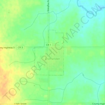
Name: Ostrander topographic map, elevation, terrain.

Location: Ostrander, Fillmore County, Minnesota, United States (43.60928 -92.43443 43.62099 -92.42398)

Average elevation: 407 m

Minimum elevation: 393 m

Maximum elevation: 425 m

Other topographic maps

Click on a map to view its topography, its elevation and its terrain.

Chatfield

United States > Minnesota > Fillmore County

Average elevation: 327 m

Highland

United States > Minnesota > Fillmore County

Average elevation: 351 m

Gear up for your next adventure:

💧Collapsible Water Bottle - Space-saving water bottle for outdoor activities
💡Portable Camping Lamp - Rechargeable lamp for campsite lighting
🥾Waterproof Trail Shoes - Shoes designed to handle wet terrain
🧭GPS Tracker - Track your location in remote areas safely
🧥Waterproof Jacket - Lightweight rain jackets for hiking and outdoor activities

As an Amazon Associate, this site earns from qualifying purchases at no extra cost to you.