Geolocate

Elkinsville topographic map

Click on the map to display elevation.

About this map

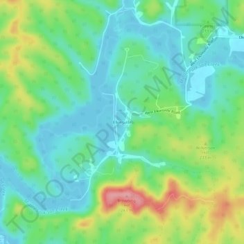
Name: Elkinsville topographic map, elevation, terrain.

Location: Elkinsville, Brown County, Indiana, United States (39.05604 -86.28286 39.09604 -86.24286)

Average elevation: 200 m

Minimum elevation: 164 m

Maximum elevation: 279 m

Gear up for your next adventure:

🧭Orienteering Kit - Tools for map reading and navigation in the wild
🥾Durable Hiking Shoes - Long-lasting shoes for frequent hiking
🦯Trekking Poles - Reduced impact on joints for steep topographic climbs
🪑Insulated Seat Pad - Protect your seat from cold rocks and wet logs
🧳Compression Sacks - Maximize space in your backpack by shrinking gear

As an Amazon Associate, this site earns from qualifying purchases at no extra cost to you.