Geolocate

Colby topographic map

Click on the map to display elevation.

About this map

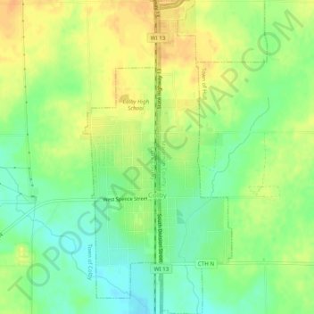
Name: Colby topographic map, elevation, terrain.

Location: Colby, Clark County, Wisconsin, 54421, United States (44.89684 -90.32726 44.93127 -90.30416)

Average elevation: 415 m

Minimum elevation: 397 m

Maximum elevation: 431 m

Other topographic maps

Click on a map to view its topography, its elevation and its terrain.

Willard

United States > Wisconsin > Clark County

Average elevation: 353 m

Chili

United States > Wisconsin > Clark County

Average elevation: 374 m

Humbird

United States > Wisconsin > Clark County

Average elevation: 319 m

Globe

United States > Wisconsin > Clark County

Average elevation: 347 m

Lynn

United States > Wisconsin > Clark County

The history of Lynn, Wisconsin is deeply rooted in the early settlement and development of Clark County. Topics covered in the history of Clark County, Wisconsin, include topography, Indians, early government, early settlement, politics, lumbering, transportation, agriculture, education, the press, the courts,…

Average elevation: 355 m

Gear up for your next adventure:

🧼Biodegradable Camp Soap - Environmentally friendly cleaning for gear and body
🪑Ultralight Camping Stool - Compact seating for rest stops during long hikes
🧥Ultralight Puffy Jacket - Maximum warmth that packs down to the size of an orange
🧥Packable Rain Jacket - Breathable waterproof layer for unpredictable weather
👟Trail Running Shoes - Agile footwear for fast-paced topographic exploration

As an Amazon Associate, this site earns from qualifying purchases at no extra cost to you.