
Thank you for supporting this site ❤️
Make a donation
Make a donation
Gear up for your next adventure:
As an Amazon Associate, this site earns from qualifying purchases at no extra cost to you.
Zlaim topographic map
Click on the map to display elevation.
Thank you for supporting this site ❤️
Make a donation
Make a donation
Gear up for your next adventure:
As an Amazon Associate, this site earns from qualifying purchases at no extra cost to you.
About this map
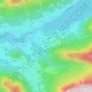
Name: Zlaim topographic map, elevation, terrain.
Location: Zlaim, Grundlsee, Bezirk Liezen, Styria, 8993, Austria (47.59426 13.81176 47.63426 13.85176)
Average elevation: 909 m
Minimum elevation: 682 m
Maximum elevation: 1,598 m
Thank you for supporting this site ❤️
Make a donation
Make a donation
Gear up for your next adventure:
As an Amazon Associate, this site earns from qualifying purchases at no extra cost to you.