
Mazarrón topographic map
Interactive map
Click on the map to display elevation.
About this map
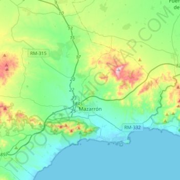
Name: Mazarrón topographic map, elevation, terrain.
Location: Mazarrón, Bajo Guadalentín, España (37.51728 -1.47576 37.72402 -1.20824)
Average elevation: 150 m
Minimum elevation: -1 m
Maximum elevation: 683 m
Other topographic maps
Click on a map to view its topography, its elevation and its terrain.
Patalache
España > Bajo Guadalentín > Aledo
Patalache, Aledo, Bajo Guadalentín, 30859, España
Average elevation: 567 m
Nonihay
España > Bajo Guadalentín > Aledo
Nonihay, Aledo, Bajo Guadalentín, 30859, España
Average elevation: 577 m