
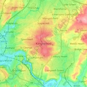
Kingswood topographic map
Interactive map
Click on the map to display elevation.
About this map
Name: Kingswood topographic map, elevation, terrain.
Average elevation: 57 m
Minimum elevation: 5 m
Maximum elevation: 131 m
Other topographic maps
Click on a map to view its topography, its elevation and its terrain.
Warmley
United Kingdom > England > South Gloucestershire
Warmley, Siston, South Gloucestershire, West of England, England, BS15 4PP, United Kingdom
Average elevation: 69 m
Marsh Common
United Kingdom > England > South Gloucestershire > Easter Compton
Marsh Common, Pilning and Severn Beach, Easter Compton, South Gloucestershire, West of England, England, BS35 4JU, United Kingdom
Average elevation: 10 m
Yate
United Kingdom > England > South Gloucestershire
Yate, South Gloucestershire, West of England, England, United Kingdom
Average elevation: 83 m
Siston
United Kingdom > England > South Gloucestershire
Siston, South Gloucestershire, West of England, England, United Kingdom
Average elevation: 80 m
Rangeworthy
United Kingdom > England > South Gloucestershire
Rangeworthy, South Gloucestershire, West of England, England, United Kingdom
Average elevation: 59 m
Alveston
United Kingdom > England > South Gloucestershire
Alveston, South Gloucestershire, West of England, England, United Kingdom
Average elevation: 75 m