Geolocate

Siston topographic map

Click on the map to display elevation.

About this map

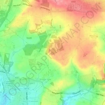
Name: Siston topographic map, elevation, terrain.

Location: Siston, South Gloucestershire, West of England, England, United Kingdom (51.45125 -2.48929 51.48151 -2.43286)

Average elevation: 80 m

Minimum elevation: 32 m

Maximum elevation: 128 m

Other topographic maps

Click on a map to view its topography, its elevation and its terrain.

Gear up for your next adventure:

🔥Camping Stove - Portable stoves to cook outdoors with ease
Family Camping Tent - Spacious tent suitable for family camping trips
🥾Waterproof Hiking Boots - Essential footwear for rugged terrain and wet Canadian trails
🚲MTB Frame Bag - Carry tools and maps directly on your bicycle frame
🧥Waterproof Pants - Keep dry during rainy hiking conditions

As an Amazon Associate, this site earns from qualifying purchases at no extra cost to you.