
Make a donation
Gear up for your next adventure:
As an Amazon Associate, this site earns from qualifying purchases at no extra cost to you.
Leherheide topographic map
Click on the map to display elevation.
Make a donation
Gear up for your next adventure:
As an Amazon Associate, this site earns from qualifying purchases at no extra cost to you.
Leherheide
Leherheide liegt auf den Ausläufern der Hohen Lieth. Im Stadtteil ist der höchste Punkt Bremerhavens, der „Leherheider Tunnelberg“. Er entstand aus einem Teil des Bodenaushubes vom Hafentunnel mit einer Höhe von 22 m ü. NHN. Der nördlichste Stadtteil grenzt im Norden an die Stadt Geestland und im Süden an den Stadtteil Lehe.
Make a donation
Gear up for your next adventure:
As an Amazon Associate, this site earns from qualifying purchases at no extra cost to you.
About this map
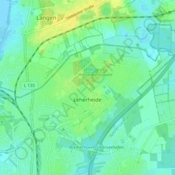
Name: Leherheide topographic map, elevation, terrain.
Average elevation: 7 m
Minimum elevation: -2 m
Maximum elevation: 20 m
Make a donation
Gear up for your next adventure:
As an Amazon Associate, this site earns from qualifying purchases at no extra cost to you.
Other topographic maps
Click on a map to view its topography, its elevation and its terrain.