Geolocate

Mörel-Filet topographic map

Click on the map to display elevation.

About this map

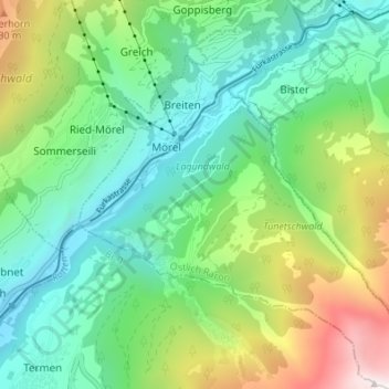
Name: Mörel-Filet topographic map, elevation, terrain.

Location: Mörel-Filet, Östlich Raron, Wallis, 3983, Switzerland (46.32583 8.02700 46.37278 8.09274)

Average elevation: 1,350 m

Minimum elevation: 694 m

Maximum elevation: 2,904 m

Other topographic maps

Click on a map to view its topography, its elevation and its terrain.

Bettmerhorn

Switzerland > Wallis > Östlich Raron > Bettmeralp

Average elevation: 2,372 m

Goppisberg

Switzerland > Wallis > Östlich Raron

Average elevation: 1,455 m

Goppisberg

Switzerland > Wallis > Östlich Raron

Average elevation: 1,455 m

Mörel

Switzerland > Wallis > Östlich Raron > Mörel-Filet

Average elevation: 1,244 m

Binntal

Switzerland > Wallis > Östlich Raron > Grengiols

Average elevation: 2,019 m

Gear up for your next adventure:

🧥Softshell Jacket - Windproof and breathable jacket for hiking
🥾All-Terrain Hiking Boots - Versatile boots for varied hiking conditions
🐕Hiking Dog Pack - Let your canine companion carry their own water and food
🥾Mountaineering Boots - Supportive boots for climbing and high-altitude hiking
Family Camping Tent - Spacious tent suitable for family camping trips

As an Amazon Associate, this site earns from qualifying purchases at no extra cost to you.