Geolocate

Kuruvikkoodu topographic map

Click on the map to display elevation.

About this map

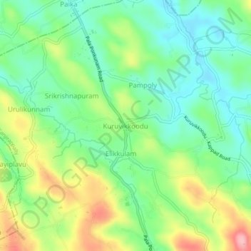
Name: Kuruvikkoodu topographic map, elevation, terrain.

Location: Kuruvikkoodu, Kanjirappally, Kottayam, Kerala, 686577, India (9.61601 76.71164 9.65601 76.75164)

Average elevation: 67 m

Minimum elevation: 15 m

Maximum elevation: 159 m

Other topographic maps

Click on a map to view its topography, its elevation and its terrain.

Elivalikkara

India > Kerala > Kanjirappally > Mukkoottuthara

Average elevation: 167 m

Mundakayam

India > Kerala > Kanjirappally > Kannimala

Average elevation: 132 m

Kanjirappilly

India > Kerala > Kanjirappally

Average elevation: 228 m

Nadukani

India > Kerala > Kanjirappally > Mundakkayam

Average elevation: 159 m

Gear up for your next adventure:

🥘Camping Cookware Set - Compact nesting pots and pans for trail cooking
🧢Hiking Sun Hat - Wide-brimmed protection for exposed mountain ridges
🌡️Emergency Mylar Blankets - Compact thermal protection for unexpected nights outdoors
🥾Trail Hiking Boots - Supportive boots for rough trails
🥾Waterproof Hiking Shoes - Durable shoes for wet and rugged trails

As an Amazon Associate, this site earns from qualifying purchases at no extra cost to you.