
Thank you for supporting this site ❤️
Make a donation
Make a donation
Gear up for your next adventure:
As an Amazon Associate, this site earns from qualifying purchases at no extra cost to you.
Augst topographic map
Click on the map to display elevation.
Thank you for supporting this site ❤️
Make a donation
Make a donation
Gear up for your next adventure:
As an Amazon Associate, this site earns from qualifying purchases at no extra cost to you.
About this map
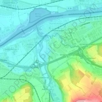
Name: Augst topographic map, elevation, terrain.
Location: Augst, Bezirk Liestal, Basel-Country, 4302, Switzerland (47.52267 7.68682 47.53978 7.73428)
Average elevation: 295 m
Minimum elevation: 258 m
Maximum elevation: 419 m
Thank you for supporting this site ❤️
Make a donation
Make a donation
Gear up for your next adventure:
As an Amazon Associate, this site earns from qualifying purchases at no extra cost to you.