
Make a donation
Gear up for your next adventure:
As an Amazon Associate, this site earns from qualifying purchases at no extra cost to you.
Weddingen topographic map
Click on the map to display elevation.
Make a donation
Gear up for your next adventure:
As an Amazon Associate, this site earns from qualifying purchases at no extra cost to you.
Weddingen
Weddingen liegt etwa zehn Kilometer nördlich der Kreisstadt Goslar und rund sechs Kilometer westlich von Vienenburg an der Bundesstraße 82 zwischen dem Südteil des Salzgitter-Höhenzugs im Westen und dem Harly-Wald im nördlichen Harzvorland auf einer Höhe von 170 m ü. NHN. Etwa einen Kilometer südlich ist Immenrode zu erreichen, weiter in der Umgebung sind die Doppelortschaft Döhren im Nordwesten, Beuchte im Nordosten und das zu Vienenburg gehörige Kloster Wöltingerode befindlich.
Make a donation
Gear up for your next adventure:
As an Amazon Associate, this site earns from qualifying purchases at no extra cost to you.
About this map
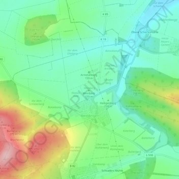
Name: Weddingen topographic map, elevation, terrain.
Average elevation: 175 m
Minimum elevation: 114 m
Maximum elevation: 301 m
Make a donation
Gear up for your next adventure:
As an Amazon Associate, this site earns from qualifying purchases at no extra cost to you.