
Make a donation
Gear up for your next adventure:
As an Amazon Associate, this site earns from qualifying purchases at no extra cost to you.
Mornico Losana topographic map
Click on the map to display elevation.
Make a donation
Gear up for your next adventure:
As an Amazon Associate, this site earns from qualifying purchases at no extra cost to you.
About this map
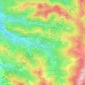
Name: Mornico Losana topographic map, elevation, terrain.
Location: Mornico Losana, Pavia, Lombardije, Italië (44.99106 9.18074 45.02110 9.23546)
Average elevation: 236 m
Minimum elevation: 108 m
Maximum elevation: 388 m
Make a donation
Gear up for your next adventure:
As an Amazon Associate, this site earns from qualifying purchases at no extra cost to you.
Other topographic maps
Click on a map to view its topography, its elevation and its terrain.
Cascina Montepagano
Italië > Lombardije > Pavia > Torrevecchia Pia > Cascina Bianca > Cascina Montepagano
Average elevation: 82 m
Make a donation
Gear up for your next adventure:
As an Amazon Associate, this site earns from qualifying purchases at no extra cost to you.