
Make a donation
Gear up for your next adventure:
As an Amazon Associate, this site earns from qualifying purchases at no extra cost to you.
Fribourg - Freiburg topographic map
Click on the map to display elevation.
Make a donation
Gear up for your next adventure:
As an Amazon Associate, this site earns from qualifying purchases at no extra cost to you.
Fribourg - Freiburg
Fribourg has an elevation of 581 metres (1,906 ft) (in the Old City), and is situated 28 kilometres (17 mi) southwest of Bern. It is located on the Swiss plateau, and extends on both sides of the Sarine, which, in the vicinity of Fribourg, has cut deeply into the molasse. The Old City is located on a hill, only about 100 metres (330 ft) wide, which rises about 40 metres (130 ft) above the valley floor. Most quarters of the city are located on the High Plateau and the surrounding hills, which have an average elevation of 620 metres (2,030 ft). The valley floor is only settled in the area immediately around the Old City.
Make a donation
Gear up for your next adventure:
As an Amazon Associate, this site earns from qualifying purchases at no extra cost to you.
About this map
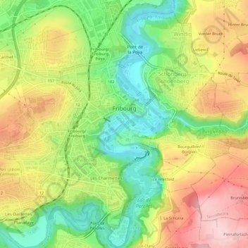
Name: Fribourg - Freiburg topographic map, elevation, terrain.
Location: Fribourg - Freiburg, Sarine District, Fribourg, Switzerland (46.78489 7.13565 46.82155 7.18397)
Average elevation: 638 m
Minimum elevation: 528 m
Maximum elevation: 760 m
Make a donation
Gear up for your next adventure:
As an Amazon Associate, this site earns from qualifying purchases at no extra cost to you.
Other topographic maps
Click on a map to view its topography, its elevation and its terrain.