
Piura topographic map
Click on the map to display elevation.
About this map
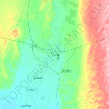
Name: Piura topographic map, elevation, terrain.
Location: Piura, 20000, Perú (-5.35711 -80.78666 -5.03711 -80.46666)
Average elevation: 69 m
Minimum elevation: 14 m
Maximum elevation: 198 m
Other topographic maps
Click on a map to view its topography, its elevation and its terrain.
Área de Conservación Regional Bosques Secos de Salitral-Huarmaca
Average elevation: 487 m
Ignacio Escudero
La capital de Ignacio Escudero es San Jacinto, pero más se le conoce como “Cerro Mocho”. Quien viaja por la Panamericana hacia Talara y a unos 25 kilómetros de Sullana, puede observar claramente un cerro como si hubiera sido cortado (ilustración). Se dice que debido a las crecidas del río Chira, los…
Average elevation: 66 m
Sechura
Es una elevación rocosa, restos de la antigua cordillera que corría paralela a la costa norte, herencia del paleozoico, con existencia de fósiles de moluscos y supracarbónicos. Su punto más alto está en los 517 m s. n. m. con una longitud de 36 km y un ancho de 18 km. Ubicado en el extremo sur-oeste del…
Average elevation: 25 m
Las Lomas
Abarca una extensión territorial de aproximadamente 522,47 km² y una altitud de 254,09 m s. n. m. Está ubicado en la costa norte del Perú, en la parte nor – oeste del Departamento de Piura, entre ambas márgenes del Río Chipillico, comprensión de la Cuenca Binacional Catamayo-Chira, entre las coordenadas.
Average elevation: 339 m
Catacaos
Se ubica en las coordenadas 5°15’42’’ de latitud sur y 80°40’27’’ de Longitud oeste; ocupa una zona de bosque seco tropical. Su topografía es plana, con tierras eriazas, en la parte este y sur del distrito, presentando una pequeña zona aluvial en la parte norte, el piso ecológico predominante es costa.
Average elevation: 68 m
Sondor
La capital del distrito es la ciudad de Sóndor, situada a una altitud de 2050 m s. n. m.. La ciudad está situada entre el Cerro Pashirca y el Cerro La Viuda; a la margen derecha de la quebrada de Sóndor. Entre los platos típicos de la gastronomía del distrito destacan la sopa de arverjas y los…
Average elevation: 2,426 m
San Miguel de El Faique
La catarata Santa Ana se encuentra ubicada en el Caserío Santa Ana, situada a una altitud de 1624 m s. n. m. y a una distancia de 9 km de San Miguel de El Faique capital distrital. La Catarata tiene una caída de agua de 40 metros aprox. que desciende de la quebrada del mismo nombre, cuya caída de agua forma…
Average elevation: 1,538 m
Sondorillo
La capital del distrito es Sondorillo, situada a una altitud de 1888 metros sobre el nivel del mar.
Average elevation: 2,397 m
Yamango
DISTRITO PRIMAVERAL Denominándose así por su clima cálido – templado permanente, se ubica al lado extremo nororiental de la Provincia de Morropón, con 216.91 km² de superficie, esta enclavado entre dos subsecuencas; su altitud fluctúa entre los 200 a 3300 m s. n. m. y los que desean visitarlo llega a 3…
Average elevation: 1,530 m
La Unión
Abarca una superficie de 213,16 km² y está situado al sur de la capital de la provincia de Piura, en las coordenadas: 05° 23' 42" de latitud sur y a 80° 44' 24" de longitud oeste, a una altitud de 17 m.s.n.m. En el mapa nacional se encuentra en la costa norte del Perú. Su capital es la homónima La Unión.
Average elevation: 33 m
Área de Conservación Privada Lagunas y Páramos de Andinos de San José de Tapal
Perú > Piura > Distrito de Ayabaca
Average elevation: 3,353 m
Catacaos
Se ubica en las coordenadas 5°15’42’’ de latitud sur y 80°40’27’’ de Longitud oeste; ocupa una zona de bosque seco tropical. Su topografía es plana, con tierras eriazas, en la parte este y sur del distrito, presentando una pequeña zona aluvial en la parte norte, el piso ecológico predominante es costa.
Average elevation: 68 m
Área de Conservación Regional Bosques Secos de Salitral-Huarmaca
Average elevation: 487 m
Las Lomas
Abarca una extensión territorial de aproximadamente 522,47 km² y una altitud de 254,09 m s. n. m. Está ubicado en la costa norte del Perú, en la parte nor – oeste del Departamento de Piura, entre ambas márgenes del Río Chipillico, comprensión de la Cuenca Binacional Catamayo-Chira, entre las coordenadas.
Average elevation: 339 m