
Make a donation
Gear up for your next adventure:
As an Amazon Associate, this site earns from qualifying purchases at no extra cost to you.
Castelromano topographic map
Click on the map to display elevation.
Make a donation
Gear up for your next adventure:
As an Amazon Associate, this site earns from qualifying purchases at no extra cost to you.
Castelromano
Sorge in un pianoro ai piedi del monte La Romana (900 m s.l.m. circa) ad un'altitudine di 720m s.l.m., distante circa 5 km ad ovest della città.
Make a donation
Gear up for your next adventure:
As an Amazon Associate, this site earns from qualifying purchases at no extra cost to you.
About this map
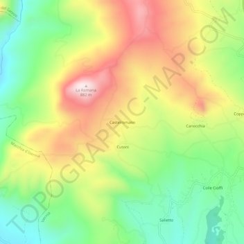
Name: Castelromano topographic map, elevation, terrain.
Location: Castelromano, Isernia, Molise, 86170, Italia (41.59893 14.17705 41.63893 14.21705)
Average elevation: 576 m
Minimum elevation: 350 m
Maximum elevation: 855 m
Make a donation
Gear up for your next adventure:
As an Amazon Associate, this site earns from qualifying purchases at no extra cost to you.