
Make a donation
Gear up for your next adventure:
As an Amazon Associate, this site earns from qualifying purchases at no extra cost to you.
Bobs Lake topographic map
Click on the map to display elevation.
Make a donation
Gear up for your next adventure:
As an Amazon Associate, this site earns from qualifying purchases at no extra cost to you.
About this map
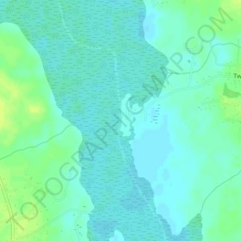
Name: Bobs Lake topographic map, elevation, terrain.
Location: Bobs Lake, Dorchester County, South Carolina, United States (32.99491 -80.29227 32.99978 -80.29165)
Average elevation: 8 m
Minimum elevation: 3 m
Maximum elevation: 19 m
Make a donation
Gear up for your next adventure:
As an Amazon Associate, this site earns from qualifying purchases at no extra cost to you.
Other topographic maps
Click on a map to view its topography, its elevation and its terrain.
Ashley Retreat
United States > South Carolina > Dorchester County > Summerville
Average elevation: 11 m
Gadsden Place
United States > South Carolina > Dorchester County > Summerville
Average elevation: 23 m
Make a donation
Gear up for your next adventure:
As an Amazon Associate, this site earns from qualifying purchases at no extra cost to you.
Make a donation
Gear up for your next adventure:
As an Amazon Associate, this site earns from qualifying purchases at no extra cost to you.
Norman Landing
United States > South Carolina > Dorchester County > Norman Landing
Average elevation: 12 m