
Make a donation
Gear up for your next adventure:
As an Amazon Associate, this site earns from qualifying purchases at no extra cost to you.
Karthikappally topographic map
Click on the map to display elevation.
Make a donation
Gear up for your next adventure:
As an Amazon Associate, this site earns from qualifying purchases at no extra cost to you.
About this map
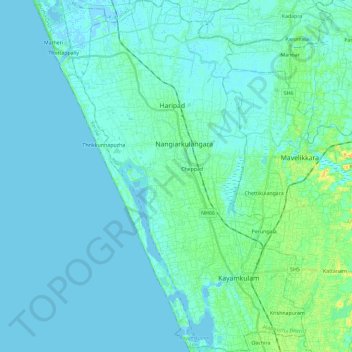
Name: Karthikappally topographic map, elevation, terrain.
Location: Karthikappally, Alappuzha, Kerala, India (9.12428 76.38588 9.35283 76.54368)
Average elevation: 4 m
Minimum elevation: -4 m
Maximum elevation: 27 m
Make a donation
Gear up for your next adventure:
As an Amazon Associate, this site earns from qualifying purchases at no extra cost to you.
Other topographic maps
Click on a map to view its topography, its elevation and its terrain.
Haripad
India > Kerala > Karthikappally
Haripad is a town and municipality in Alappuzha District of Kerala State in India. Its coordinates are Latitude: 9°18′0″N and Longitude: 76°28′0″E, and lies at an elevation of 13 meters. It is bordered on the east by Pallippad, Karuvatta to the north, Kumarapuram and Mahadevikadu to the West, and on…
Average elevation: 4 m