Geolocate

Nile topographic map

Click on the map to display elevation.

About this map

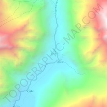
Name: Nile topographic map, elevation, terrain.

Location: Nile, Chum Nubri, Gorkha, Gandaki Province, Nepal (28.52369 85.08553 28.56369 85.12553)

Average elevation: 3,922 m

Minimum elevation: 3,228 m

Maximum elevation: 5,175 m

Other topographic maps

Click on a map to view its topography, its elevation and its terrain.

Gorkha

Nepal > Gandaki Province > Gorkha

Average elevation: 787 m

Chum Nubri

Nepal > Gandaki Province > Gorkha

Average elevation: 4,445 m

Chum Nubri

Nepal > Gandaki Province > Gorkha

Average elevation: 4,445 m

Gear up for your next adventure:

🔥Emergency Fire Starter - Reliable ignition source for all weather conditions
🧦Crew Hiking Socks - Comfortable socks for long-distance hikes
🔦LED Headlamp - Hands-free lighting for early morning starts or late finishes
🚲MTB Frame Bag - Carry tools and maps directly on your bicycle frame
🧴Waterproofing Spray - Restore the DWR coating on jackets and tents

As an Amazon Associate, this site earns from qualifying purchases at no extra cost to you.