Geolocate

Ogassa topographic map

Click on the map to display elevation.

About this map

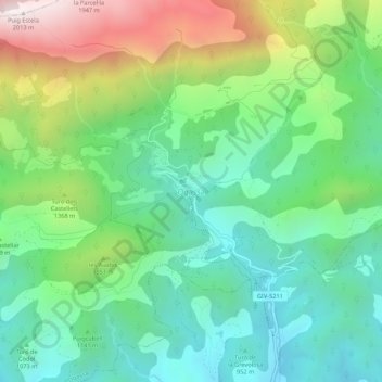
Name: Ogassa topographic map, elevation, terrain.

Location: Ogassa, Ripollés, Gerona, Cataluña, 17861, España (42.24563 2.25778 42.28563 2.29778)

Average elevation: 1,194 m

Minimum elevation: 810 m

Maximum elevation: 2,008 m

Gear up for your next adventure:

🥾Trail Hiking Boots - Supportive boots for rough trails
🧰Survival Kit - Essential gear for emergencies in the wilderness
🧰Emergency Multi-Tool - Compact multi-tool for outdoor survival
Lightweight Backpacking Tent - Compact tent for efficient hiking trips
🧥Packable Rain Jacket - Breathable waterproof layer for unpredictable weather

As an Amazon Associate, this site earns from qualifying purchases at no extra cost to you.