
Thank you for supporting this site ❤️
Make a donation
Make a donation
Gear up for your next adventure:
As an Amazon Associate, this site earns from qualifying purchases at no extra cost to you.
Tejar topographic map
Click on the map to display elevation.
Thank you for supporting this site ❤️
Make a donation
Make a donation
Gear up for your next adventure:
As an Amazon Associate, this site earns from qualifying purchases at no extra cost to you.
About this map
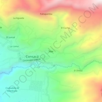
Name: Tejar topographic map, elevation, terrain.
Location: Tejar, Consacá, Occidente, Nariño, RAP Pacífico, Colombia (1.19041 -77.47823 1.23041 -77.43823)
Average elevation: 1,910 m
Minimum elevation: 1,390 m
Maximum elevation: 2,666 m
Thank you for supporting this site ❤️
Make a donation
Make a donation
Gear up for your next adventure:
As an Amazon Associate, this site earns from qualifying purchases at no extra cost to you.