Geolocate

Tanete topographic map

Click on the map to display elevation.

About this map

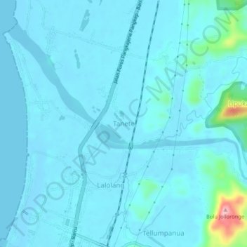
Name: Tanete topographic map, elevation, terrain.

Location: Tanete, Barru, South Sulawesi, Sulawesi, Indonesia (-4.48469 119.59541 -4.44469 119.63541)

Average elevation: 15 m

Minimum elevation: -4 m

Maximum elevation: 172 m

Gear up for your next adventure:

🥾Trail Running Shoes - Lightweight and durable shoes for trail running
🧼Travel Hand Sanitizer - Keep hands clean when water is scarce
🧳Compression Sacks - Maximize space in your backpack by shrinking gear
🛌Down Sleeping Bag - Superior warmth-to-weight ratio for cold nights
🥾Trail Running Boots - Durable shoes designed for trail running

As an Amazon Associate, this site earns from qualifying purchases at no extra cost to you.