Geolocate

Newtown topographic map

Click on the map to display elevation.

About this map

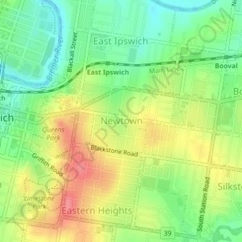
Name: Newtown topographic map, elevation, terrain.

Location: Newtown, Ipswich City, Queensland, Australia (-27.62025 152.77050 -27.61273 152.78347)

Average elevation: 37 m

Minimum elevation: 2 m

Maximum elevation: 79 m

Other topographic maps

Click on a map to view its topography, its elevation and its terrain.

Stanton Cross

Australia > Queensland > Ipswich City

Average elevation: 28 m

Mount Grey

Australia > Queensland > Ipswich City

Average elevation: 231 m

Spring Mountain

Australia > Queensland > Ipswich City

Average elevation: 190 m

White Rock

Australia > Queensland > Ipswich City

Average elevation: 114 m

Gear up for your next adventure:

🥾Trail Hiking Socks - Comfortable socks to prevent blisters and fatigue
🧭GPS Handheld Device - Reliable GPS navigation for outdoor adventures
🌬️Windproof Camp Stove - Efficient cooking even on exposed mountain peaks
🦶Anti-Blister Balm - Prevents friction and hotspots during long ascents
🥾Waterproof Hiking Shoes - Durable shoes for wet and rugged trails

As an Amazon Associate, this site earns from qualifying purchases at no extra cost to you.