
Thank you for supporting this site ❤️
Make a donation
Make a donation
Gear up for your next adventure:
As an Amazon Associate, this site earns from qualifying purchases at no extra cost to you.
Agramunt topographic map
Click on the map to display elevation.
Thank you for supporting this site ❤️
Make a donation
Make a donation
Gear up for your next adventure:
As an Amazon Associate, this site earns from qualifying purchases at no extra cost to you.
About this map
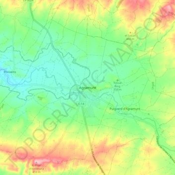
Name: Agramunt topographic map, elevation, terrain.
Location: Agramunt, Urgel, Lérida, Catalogne, 25310, Espagne (41.74767 1.05868 41.82767 1.13868)
Average elevation: 365 m
Minimum elevation: 306 m
Maximum elevation: 460 m
Thank you for supporting this site ❤️
Make a donation
Make a donation
Gear up for your next adventure:
As an Amazon Associate, this site earns from qualifying purchases at no extra cost to you.