Geolocate

Calo topographic map

Click on the map to display elevation.

About this map

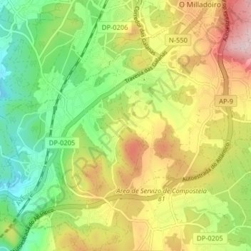
Name: Calo topographic map, elevation, terrain.

Location: Calo, Teo, Santiago, La Coruña, Galicia, 15866, España (42.79789 -8.62892 42.84558 -8.56120)

Average elevation: 179 m

Minimum elevation: 39 m

Maximum elevation: 348 m

Other topographic maps

Click on a map to view its topography, its elevation and its terrain.

Agoso

España > Galicia > Teo

Average elevation: 111 m

A Ramallosa

España > Galicia > Teo

Average elevation: 139 m

Rial do Mato

España > Galicia > Teo

Average elevation: 191 m

O Casal de Reis

España > Galicia > Teo

Average elevation: 140 m

O Aido

España > Galicia > Teo

Average elevation: 199 m

Penelas

España > Galicia > Teo

Average elevation: 194 m

Feros

España > Galicia > Teo

Average elevation: 182 m

Gear up for your next adventure:

🐕Hiking Dog Pack - Let your canine companion carry their own water and food
📷Outdoor Action Camera - Capture high-elevation views and rugged adventures
🗺️Topographic Maps - Detailed maps to explore trails, mountains, and wilderness areas
🥾Hiking Leggings - Comfortable leggings for outdoor activities
🥾Light Trekking Boots - Supportive boots for multi-day treks

As an Amazon Associate, this site earns from qualifying purchases at no extra cost to you.