Geolocate

Vaale topographic map

Click on the map to display elevation.

About this map

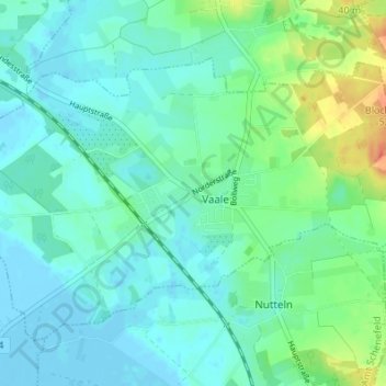
Name: Vaale topographic map, elevation, terrain.

Location: Vaale, Schenefeld, Steinburg, Schleswig-Holstein, 25594, Germany (53.97934 9.35256 54.01934 9.39256)

Average elevation: 11 m

Minimum elevation: -3 m

Maximum elevation: 47 m

Gear up for your next adventure:

🥾Waterproof Hiking Boots - Essential footwear for rugged terrain and wet Canadian trails
🧴Outdoor Sunscreen - High SPF protection for high-altitude UV exposure
🥾Waterproof Trail Shoes - Shoes designed to handle wet terrain
🧢Outdoor Visor - Breathable visor for sunny hikes
🥾All-Terrain Hiking Boots - Versatile boots for varied hiking conditions

As an Amazon Associate, this site earns from qualifying purchases at no extra cost to you.