Geolocate

Hanalei topographic map

Click on the map to display elevation.

About this map

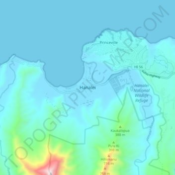
Name: Hanalei topographic map, elevation, terrain.

Location: Hanalei, Kauaʻi County, Hawaii, 96714, United States (22.16299 -159.53569 22.24299 -159.45569)

Average elevation: 110 m

Minimum elevation: 0 m

Maximum elevation: 1,112 m

Gear up for your next adventure:

🧊Insulated Water Bottle - Keeps drinks cold in summer and prevents freezing in winter
🧴Outdoor Sunscreen - High SPF protection for high-altitude UV exposure
Camping Essentials - All-in-one gear for a comfortable camping trip
🚲Heavy Duty Bike Lock - Secure your bike at the trailhead or during stops
🦶Anti-Blister Balm - Prevents friction and hotspots during long ascents

As an Amazon Associate, this site earns from qualifying purchases at no extra cost to you.