Geolocate

Paparoa topographic map

Click on the map to display elevation.

About this map

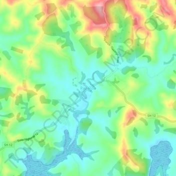
Name: Paparoa topographic map, elevation, terrain.

Location: Paparoa, Kaipara District, Northland, 0571, New Zealand (-36.11998 174.21479 -36.07998 174.25479)

Average elevation: 52 m

Minimum elevation: 0 m

Maximum elevation: 149 m

Other topographic maps

Click on a map to view its topography, its elevation and its terrain.

Wairoa River

New Zealand > Northland > Kaipara District

Average elevation: 42 m

Lake Kaiiwi

New Zealand > Northland > Kaipara District

Average elevation: 79 m

Lake Rototuna

New Zealand > Northland > Kaipara District

Average elevation: 120 m

Gear up for your next adventure:

🧴Outdoor Sunscreen - High SPF protection for high-altitude UV exposure
🛶Waterproof Dry Bags - Keep electronics and clothes dry during river crossings
🔋Lithium AA Batteries - Long-lasting power that performs in extreme cold
🔦UV Flashlight - Detect minerals or specific insects in the dark
🧰Multitool Knife - Compact and versatile tool for outdoor use

As an Amazon Associate, this site earns from qualifying purchases at no extra cost to you.