
Thank you for supporting this site ❤️
Make a donation
Make a donation
Gear up for your next adventure:
As an Amazon Associate, this site earns from qualifying purchases at no extra cost to you.
Cune topographic map
Click on the map to display elevation.
Thank you for supporting this site ❤️
Make a donation
Make a donation
Gear up for your next adventure:
As an Amazon Associate, this site earns from qualifying purchases at no extra cost to you.
About this map
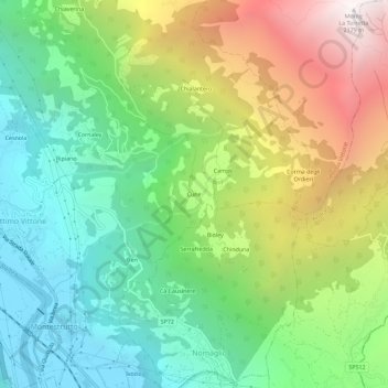
Name: Cune topographic map, elevation, terrain.
Location: Cune, Settimo Vittone, Torino, Piemonte, 10013, Italia (45.53253 7.83805 45.57253 7.87805)
Average elevation: 960 m
Minimum elevation: 253 m
Maximum elevation: 2,177 m
Thank you for supporting this site ❤️
Make a donation
Make a donation
Gear up for your next adventure:
As an Amazon Associate, this site earns from qualifying purchases at no extra cost to you.