
Thank you for supporting this site ❤️
Make a donation
Make a donation
Gear up for your next adventure:
As an Amazon Associate, this site earns from qualifying purchases at no extra cost to you.
Bustelo topographic map
Click on the map to display elevation.
Thank you for supporting this site ❤️
Make a donation
Make a donation
Gear up for your next adventure:
As an Amazon Associate, this site earns from qualifying purchases at no extra cost to you.
About this map
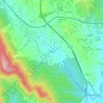
Name: Bustelo topographic map, elevation, terrain.
Location: Bustelo, Recarei, Paredes, Porto, Norte, 4585-645, Portugal (41.13039 -8.46362 41.17039 -8.42362)
Average elevation: 157 m
Minimum elevation: 64 m
Maximum elevation: 380 m
Thank you for supporting this site ❤️
Make a donation
Make a donation
Gear up for your next adventure:
As an Amazon Associate, this site earns from qualifying purchases at no extra cost to you.