Geolocate

Washington topographic map

Click on the map to display elevation.

About this map

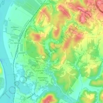
Name: Washington topographic map, elevation, terrain.

Location: Washington, Wood County, West Virginia, United States (39.22258 -81.69163 39.26259 -81.64496)

Average elevation: 208 m

Minimum elevation: 171 m

Maximum elevation: 266 m

Other topographic maps

Click on a map to view its topography, its elevation and its terrain.

Deerwalk

United States > West Virginia > Wood County

Average elevation: 282 m

Belleville

United States > West Virginia > Wood County

Average elevation: 207 m

Lee Creek

United States > West Virginia > Wood County

Average elevation: 205 m

Slate

United States > West Virginia > Wood County

Average elevation: 225 m

Ogden

United States > West Virginia > Wood County

Average elevation: 249 m

Gear up for your next adventure:

🥾Approach Shoes - Shoes designed for climbing approaches and rugged trails
🧥Waterproof Jacket - Lightweight rain jackets for hiking and outdoor activities
🥾Light Hiking Boots - Lightweight and comfortable boots for day hikes
🧢Outdoor Cap - Protective cap for sun and rain during hikes
🚲Handlebar Phone Mount - View topographic-map.com live while cycling

As an Amazon Associate, this site earns from qualifying purchases at no extra cost to you.