Geolocate

Mount Cayabu topographic map

Click on the map to display elevation.

About this map

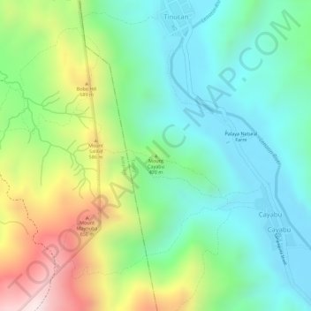
Name: Mount Cayabu topographic map, elevation, terrain.

Location: Mount Cayabu, Cayabu, Tanay, Rizal, Calabarzon, Philippines (14.66793 121.33225 14.66803 121.33235)

Average elevation: 418 m

Minimum elevation: 235 m

Maximum elevation: 762 m

Gear up for your next adventure:

🔭Outdoor Binoculars - Lightweight binoculars for birdwatching and hiking
🧭GPS Tracker - Track your location in remote areas safely
🥾Hiking Shorts - Breathable shorts suitable for summer hikes
💧Filtered Water Bottle - Safe drinking water on the go
🥾Light Trekking Boots - Supportive boots for multi-day treks

As an Amazon Associate, this site earns from qualifying purchases at no extra cost to you.