
Make a donation
Gear up for your next adventure:
As an Amazon Associate, this site earns from qualifying purchases at no extra cost to you.
Muğla topographic map
Click on the map to display elevation.
Make a donation
Gear up for your next adventure:
As an Amazon Associate, this site earns from qualifying purchases at no extra cost to you.
Muğla
Muğla (Turkish: [ˈmuːɫa]) is a city in southwestern Turkey. The city is the center of the district of Menteşe and Muğla Province, which stretches along Turkey's Aegean coast. Muğla's center is situated inland at an altitude of 660 m and lies at a distance of about 30 km (19 mi) from the nearest seacoast in the Gulf of Gökova to its south-west. Muğla (Menteşe) district area neighbors the district areas of Milas, Yatağan and Kavaklıdere to its north by north-west and those of Ula and Köyceğiz, all of whom are dependent districts. Muğla is the administrative capital of a province that incorporates internationally well-known and popular tourist resorts such as Bodrum, Marmaris, Datça, Dalyan, Fethiye, Ölüdeniz and also the smaller resort of Sarigerme.
Make a donation
Gear up for your next adventure:
As an Amazon Associate, this site earns from qualifying purchases at no extra cost to you.
About this map
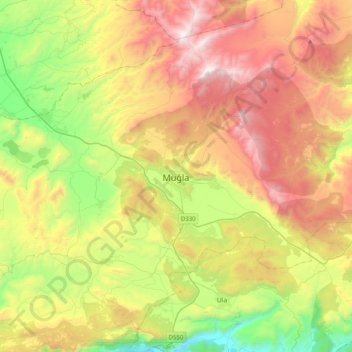
Name: Muğla topographic map, elevation, terrain.
Location: Muğla, Menteşe, Muğla, Aegean Region, 48050, Turkey (37.05518 28.20373 37.37518 28.52373)
Average elevation: 841 m
Minimum elevation: 23 m
Maximum elevation: 1,882 m
Make a donation
Gear up for your next adventure:
As an Amazon Associate, this site earns from qualifying purchases at no extra cost to you.