Geolocate

Sulah topographic map

Click on the map to display elevation.

About this map

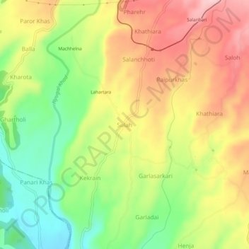
Name: Sulah topographic map, elevation, terrain.

Location: Sulah, Palampur, Kangra, Himachal Pradesh, 176085, India (32.03868 76.45180 32.07868 76.49180)

Average elevation: 944 m

Minimum elevation: 839 m

Maximum elevation: 1,049 m

Other topographic maps

Click on a map to view its topography, its elevation and its terrain.

Nanahar

India > Himachal Pradesh > Palampur

Average elevation: 1,610 m

Dhauladhar

India > Himachal Pradesh > Palampur

Average elevation: 2,577 m

Banuri

India > Himachal Pradesh > Palampur

Average elevation: 1,254 m

Neugal Rivulet

India > Himachal Pradesh > Palampur

Average elevation: 1,019 m

Kandbari

India > Himachal Pradesh > Palampur

Average elevation: 1,424 m

Gear up for your next adventure:

🧥Ultralight Puffy Jacket - Maximum warmth that packs down to the size of an orange
🧭GPS Handheld Device - Reliable GPS navigation for outdoor adventures
🌡️Emergency Mylar Blankets - Compact thermal protection for unexpected nights outdoors
💧Hydration Pack - Hands-free hydration system for long hikes
🧦Crew Hiking Socks - Comfortable socks for long-distance hikes

As an Amazon Associate, this site earns from qualifying purchases at no extra cost to you.