Geolocate

Jiantang topographic map

Click on the map to display elevation.

About this map

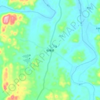
Name: Jiantang topographic map, elevation, terrain.

Location: Jiantang, Guilin, Guangxi, China (25.83050 111.01400 25.91050 111.09400)

Average elevation: 219 m

Minimum elevation: 149 m

Maximum elevation: 497 m

Other topographic maps

Click on a map to view its topography, its elevation and its terrain.

Pingle County

China > Guangxi > Guilin

Average elevation: 390 m

Xiangshan District

China > Guangxi > Guilin

Average elevation: 179 m

Yangshuo County

China > Guangxi > Guilin

Average elevation: 319 m

Yangshuo County

China > Guangxi > Guilin

Average elevation: 319 m

Gear up for your next adventure:

🧊Portable Cooler - Keep food and drinks cold during outdoor adventures
🦶Hiking Shoe Insoles - Added support for high arches and long days on feet
🥫Freeze-Dried Meals - Lightweight, high-calorie nutrition for multi-day treks
🧥Softshell Jacket - Windproof and breathable jacket for hiking
🧥Waterproof Pants - Keep dry during rainy hiking conditions

As an Amazon Associate, this site earns from qualifying purchases at no extra cost to you.